Decongesting Bangalore By Promoting Shared Mobility

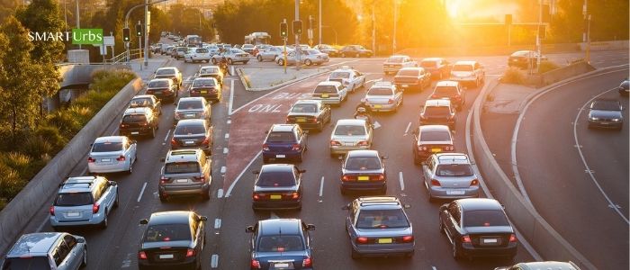
In fast-growing metropolitan regions, traffic congestion has become a key concern influenced by economics, population growth, transportation infrastructure, and the ever-increasing availability of ridesharing and delivery services. Although larger cities generally exhibit higher congestion levels the negative consequences of traffic, including the loss of time, increase in urban pollution, and risk of accidents, is pervasive throughout many urban centers. The delays caused by congestion have effectively contracted business markets and raised production costs by reducing urban agglomeration economies.

In recent decades, Bengaluru as a metropolis has witnessed explosive growth – both in terms of population, which has doubled since 2001, and growth in vehicles, which has more than quadrupled in the same period. With a vehicle ownership rate of about 780 vehicles per 1,000 persons that contribute to about 10 million tons of CO2 annually. This has significantly stressed the city’s road infrastructure, leading to congestion and increases in pollution. As per the Comprehensive Mobility Plan for Bengaluru, an average citizen of Bengaluru spends more than 240 hours stuck in traffic every year. For some time, the lack of transport-oriented development policies, and inefficient public transportation system, combined with unmanaged land use and narrow roads, contributed to its congestion issues.

As Bengaluru is a ring-radial patterned city similar to Delhi, Hyderabad and Ahmedabad, so it doesn’t have a well-formed grid network – thus, longer travel times, compared to a linear city. Also, as per CMP Bangalore, nearly 84% of households have motor vehicles- about 20% have one car, and 60% of households have at least 1 scooter/motorcycle. And 48% of the total trips are contributed by public transport, much lower than Mumbai, Kolkata which is 80% followed by two-wheelers (23.5%) and car/taxi (21%). On average, the city witnesses approximately 100 – 110 lakh trips every day, out of which 35 – 42 lakh trips are on BMTC buses, 4 – 4.5 lakh trips are on Metro and about 1.5- 2 lakhs trips on Suburban Rail. The average trip length is 1.0 Km by walk, for 2-wheelers 9.8 km, for car and taxi is 10.2 km and 13.1 km and for Bus it is about 12 km. Analyzing the mode share, public transport in the city has failed to keep up with the demands of its rapidly expanding urban population, while travel characteristics and socio-economic aspects such as high working population, lower travel distances and rising congestion levels are in favor of public transport. Therefore, a shift from private to public transport could be incentivized to address the issues.

Presently, public transport in Bangalore consists of several intra-city commute modes such as BMTC buses, Namma Metro rail services, taxis and auto-rickshaws, among intercity forms of transport: Government operated KSRTC, NWKRTC, KKRTC, other states RTC buses, Private bus operators, and trains. Although BMTC buses are considered to be the lifeline of the city with a fleet of 6650 buses and average ridership of 51 lakh, each bus takes 5-6 round trips. Railways, within Bengaluru and suburban areas, make about 120 trips per day and have a ridership of 1.5 lakh approximately and the metro has a share of 4.5 lakh. But, the actual ridership is different as each ticket they buy is considered in the ridership.

In metro and railway generally, tickets are purchased before boarding and for the entire journey but for buses at every interchange there is a need to buy fresh tickets, hence fluctuating the rideshare data. Bangalore public transport has issues with last-mile connectivity- to avail of any services, one has to opt for multiple modes. Lakhs of people would have used multiple buses to go to a destination that doesn’t have a direct bus. These commuters would also have taken the Metro if the bus is a feeder bus. Also, a significant amount of time is being lost in interchange, this also creates discomfort among users. The volume of ridership to capacity ratio of buses is also high, therefore promoting private vehicles ownership.

So, the Bengaluru mass transit/ public transport system needs to undergo massive improvement to be perceived as an attractive, accessible, and reliable substitute for private commuting options. This process will entail addressing several barriers obscuring accessibility to public transport, such as long travel times, limited or lack of dynamic passenger information to commuters and limited or lack of seamless first and last-mile connectivity.

POLICY MEASURES TO ENHANCE THE PUBLIC TRANSPORTATION SYSTEM OF BANGALORE

Expand reach and augment the capacity of public transport systems- The areas of operation of existing public transportation systems, both road-based and rail-based, should be expanded across the city to offer commuters convenient mobility alternatives. In addition to increasing the capacity of current networks to provide frequent and reliable transportation services for passengers during peak and off-peak hours.

Improving the operational efficiency of public transportation systems- While the development of infrastructure and capacity for public transportation is vital, these systems must also achieve operational efficiency to improve passenger convenience and throughput. Bengaluru Metro has a large potential capacity throughout, enhancing the passenger experience by providing optimized service frequency on-time performance.

Integrated Ticketing System- Presently, there is no formal integration of ticketing for Metro and BMTC users. The smart card-based automatic fare collection system which provides for seamless ticketing needs to be integrated at the earliest.

Improving perceptions of buses- There is a perception (primarily class-based) that metros are far more convenient and attractive than buses. Instead of pandering to this bias – at huge expense – in metros, tickets are typically purchased before boarding, or contactless payment options are available, and there are multiple entrances for boarding and alighting, saving time and enhancing customer experience. Presently in India and globally, there are two- and three-door variants available for buses, but bus operators generally prefer single-door buses as they offer more seating space and are simple and easy to prevent fare skipping. The advantage of considering additional doors bus models, especially once ticketing is streamlined, would be that dwell times may be significantly reduced, allowing buses to operate more frequently and boosting hourly capacity for just a minor increase in overhead.

Promote shared mobility for first and last-mile connectivity: First and last-mile connectivity plays an important role in promoting the use of public transport but for Bangalore lack of connectivity to public transit from inner localities and unavailability of shared mobility services such as IPT, bike ride-sharing, e-rickshaws, e- scooters, feeder uses, shuttle services etc. So, park and ride services can be developed and re-defined catering differently to local and longer-distance traffic. Travel hubs can be developed across the city for seamless connectivity. This will also improve the perception of the buses.

Augmenting Inbound flow technique to manage the traffic- It is a powerful technique for managing morning and evening peak traffic flows efficiently, and for providing bus priority without the need to build bus lanes right into a city.

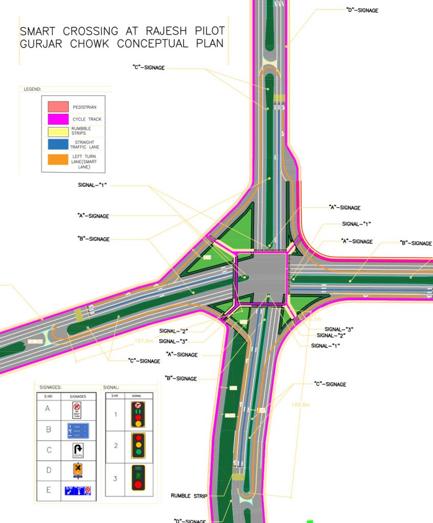
Alternative transportation infrastructure- To increase the use of alternative transportation methods, such as bike lanes, carpool lanes, bus-only lanes, bus tunnels or streetcar tracks, and more. It is being observed that the degree of effectiveness expected from these types of designated alternative-transit infrastructures is increased by their degree of separation from conventional vehicle lanes. Thus, completely separated lanes or exclusive spaces more effectively streamline traffic than simply painting lanes or messages on existing pavement.

Decarbonizing public transport system- Electrifying the inter-city and intra-city buses in phases by retrofitting the existing buses and replacing the old fleet with new low carbon emission vehicles.

Creating compact cities that reduce distances to public transport- increasing land density and incorporating land-use diversity in the planning and development of cities can encourage the use of walking, shared mobility, NMT and mass transit. This approach will not only reduce congestion on roads but will contribute significantly towards reducing local air pollution.

Establishing a unified transport governing authority/ agency for MAaS Integration- Establishing a mechanism for planning, capacity building and accountability fragmentation in the governance of urban transport leads to conflicting objectives and inequitable distribution of transport investments. The establishment of a single organization at the city level is necessary for integrated planning of mobility infrastructure, coordination among different public agencies responsible for mobility services, capacity building in transit agencies for optimization of mobility services, development of a framework for accountability of those agencies, advisory role to State Government for regulatory functions, and the setting up of common infrastructure to different service providers for greater multi-modal integration.

Conclusion
Traffic congestion is driven by many factors, including insufficient public/mass transportation infrastructure, and the need to travel is changing with the scale of the economy, rapid urbanization, globalization, etc. These measures could only fulfil the demands in the short run, further, it needs to be scaled in response to demand. Therefore, additional urban infrastructure, such as road network length, mass transport systems (metro, trams, etc.), urban density, and smart traffic solutions, must be enhanced in tandem with the city’s economic growth.

Source: Limited, Infrastructure development corporation (Karnataka). 2018. Comprehensive Mobility Plan for Bangalore. Urban development department, GoK, Karnataka: Bangalore Metro Rail limited, Directorate of Urban Land Transport, Urban development department, GoK. Accessed March 24, 2022. https://kannada.bmrc.co.in/FileUploads/2e1d9d_CareerFiles.pdf.

Smart Crossing Design Approach for Rajesh Pilot Gurjar Chowk, Gurugram

To tackle the mammoth task of reducing traffic congestion and its harmful effects on the society, a patented concept called “Smart Crossing” by SmartUrbs came into existence. The initiative is focused on reducing traffic congestion, reducing the traffic queue length, reducing traffic pollution levels, and reducing commute waiting time at red lights while ensuring the safety of all commuters.

Smart Crossing is a traffic signal management design that converts a 4-phase crossing into a 2-phase crossing. This means that two lanes on opposite sides of a signal can operate simultaneously. However, vehicles can only move straight ahead or take a left turn. To take a right turn, they would have to turn left and make a U-turn. When the signal changes, they can move straight ahead. Studies on its efficacy have shown that Smart Crossing can reduce traffic congestions by up to 80%. Since two lanes can operate simultaneously, the number of signal changes at each junction is also reduced. This means that when a car moves from one signal to the next, the chances of getting a green light with SmartUrbs increases by 50%.

This article will speak about the design of the Smart Crossing plan by SmartUrbs for experimentation in design and modeling. The location selected was Rajesh Pilot Gurjar Chowk, Sector 61, Gurugram, Haryana, one of the mid-sized, busiest junctions in the city.

Objective:

  • To quantify the impact of changing the geometry and traffic circulation scheme of a 4-way junction using the Custom Turns on traffic, with performance measures such as delays and queue lengths on junctions using a microsimulation model.
  • To estimate the capacity of the junction with and without the Custom Turn scheme using a microsimulation model.
  • To identify scenarios best suited to the implementation of Custom Turns in terms of traffic flow parameters such as volume and the geometry of the road.

Design Approach


The design of the Smart Crossing includes the implementation IRC (Indian Roads Congress) standards along with the patented idea. Intersections are a critical element of the road sections and should be designed in such a way that it minimizes the conflicts due to crossing, merging and diverting traffic. Intersections should be uniformly designed as per IRC standard and uniformity in design should be maintained as it is the key because even a newcomer in the area can anticipate what is expected at the intersections.

To maintain uniformity, intersection design included intersection, curves, vehicle turning paths and radius, super elevations, level shoulder width, speed change, lane lengths, channelization, and various types of signs and markings.

Let’s take a look at what features were included in the whole designing process.

Footpath

Footpaths were included in the design and were placed on both sides of the road, above the level of the carriageway separated by non-mountable kerbs. The width of the footpath was around 1.8 m to accommodate pedestrians during peak hours.

Pedestrian Guardrail

An important design element, the pedestrian guardrail was also added which would prevent indiscriminate crossing and stop people to get on the carriageway. It was strategically placed at hazardous locations such as junctions, schools, bus stops etc.

Pedestrian Crossing

The pedestrian crossing was included at places where vehicular traffic and pedestrian movement intersected. Zebra crossings were included for enhanced and guided movement of vehicle and pedestrian safety.

Island

The traffic islands are designed and retrofitted to match existing ground conditions and
manage the efficient movement of vehicular traffic.

Road Markings

New road and traffic markings were included in the design. Arrows were also painted on the carriageway which meant to give direction for the driver.

Signage

Signage is an important aspect of the design. Various traffic signages were placed strategically all over the junction in each and every arm as it would help commuters find the direction and aid in traffic movement. It makes the junction intuitive and facilitates the driver while maneuvering through the smart junction. The list of Signage are as follows:

  • U-turn
  • No Right turn
  • Compulsory Left or Straight
  • Stop Sign
  • Pedestrian Crossing ahead
  • Directional Sign Board
  • Overhead Sign Board with Cantilever
  • Overhead Sign Board

Since Smart Crossing is a new concept some custom signages were used. They are:

  • Smart junction ahead
  • For Right take left and U-turn
  • Custom warning Message

Traffic Signals

There were three types of traffic signals used in this design.

  • Dedicated traffic signal for left-turners,
  • Dedicated signal for pedestrian and cyclist and
  • Stop line signals on the main roads

Cycle Tracks

The design included a cycle track on either side of the road. The cycle track was designed with proper safety measures taken into account.

Rumble Stirps

The design also includes Rumble strips to slow down the traffic speed while crossing C Turn points.

Colour Strips

The design included colour stips to make the junction more intuitive. Colour stripes were used to separate the smart crossing lane and straight going traffic lane. Pink strips were used to indicate the cycle track, orange stripes were used to indicate the smart crossing lane and blue for straight moving vehicles.

This design of Smart Crossing comes bearing its own set of benefits such as:

  • Can reduce the government’s cost of making flyovers for at least 10 years
  • Eliminate traffic congestion at the junction
  • Ensures the safety of commuters
  • Reduces the waiting time at the junction
  • Provides a cost-efficient solution

If the results of this design are to be believed, this concept reduced the congestion by up to 80% when compared to the existing system of road crossings.

Want to implement SmartUrbs in your city? Get in touch with us now!

SmartUrbs successfully conducts a pilot for smart crossing in Noida

SmartUrbs successfully conducted a pilot run of its patented intersection design to convert a 4-phase traffic signal to a 2-phase signal last month at the Sector-105 Hajipur Intersection in Noida.

In the existing 4-phase crossing, a vehicle has to wait for all three sides to pass before the signal turns green. This results in elongated queues and congestion at every lane. Smart Crossing converts this conventional 4-phase traffic signal to 2 phase signal, by turning the two opposite signals green at a time. It prohibits to take a right turn, resulting in a smooth flow of traffic from two opposite lanes at a time. In order to turn right from the crossing, one has to take a left turn, followed by a c-turn.

The essence of this concept lies in the fact that c-turns are only allowed when the signal for a c-turn is green so that a vehicle can easily take c-turn without conflicting with the prevailing traffic on that lane. Watch the concept video here.

The test run enabled commuters traveling to Sector 100 from the Hajipur underpass to travel in a straight line without any traffic congestion as there is no need for a right turn and hence the traffic doesn’t stop unnecessarily.

The traffic police helped run the trial by ensuring that the experiment takes place smoothly and provided their full assistance to the SmartUrbs team. There were initial challenges like people were trying to move right even after restriction. This was resolved with adequate signages and pavement marking. With splitter placed before the junction to split straight and left-turning movement, now commuters are guided to stay left in order to take the right turn.

The SmartUrbs intersection design implementation has been finalized by the authorities after the pilot run was successful at the Hajipur intersection. The SmartUrbs intersection design has helped authorities to reduce congestion by 50% (queue length).

Smart-crossing is a very beneficial solution as it has the same impact that large investment projects such as the construction of flyovers or underpass make at a fraction of investment. The project enables more efficient and effective utilization of budgetary investments made by the government.

If the results of this simulation are to be believed, this concept reduced the congestion by up to 80% when compared to the existing system of road crossings.

Want to implement SmartUrbs in your city? Get in touch with us now!

How To Reduce Traffic Congestion In Metropolitan Cities With SMARTurbs

When you ask for direction to a place, you’re often more likely to get an answer in minutes rather than kilometers. Crossing a distance of 5 kilometers can often take up to 20 minutes depending on the traffic. In 2017, commuters in the 15 most congested cities across the world spent an average of 83 hours in traffic. And, this is not just during rush hour. The study showed that about 33% of traffic delays occurred outside peak hours. Thus, finding a solution to unlock the gridlock is the need of the hour.

Temporary Vs Virtuous Congestion-Reduction Measures

Measure to reduce traffic congestion can be categorized as temporary and virtuous.
Measures such as widening roads, building tunnels and flyovers, more car parks, etc., fall into the first category. These measures may ease current traffic congestion but once the number of vehicles on the roads increases, the results will be nullified, they may also require months of work that disrupt the flow of traffic and compromise existing infrastructure. For example, widening a road may marrow the walkway for pedestrians.
Virtuous measures to reduce traffic congestion take a more long-term approach. These changes focus on improving the flow of traffic and encouraging a shift from private cars to public transport. For example, changing the way traffic moves at junctions, making the bus service in a city safer and more reliable and stricter enforcement of traffic rules.

SMARTurbs As A Solution

Traffic congestion is often highest around crossings and road junctions. With traffic coming from 4 directions, vehicles from each side have to wait for all the other three sides to pass before getting their turn. This results in long waiting times. In cases of consecutive junctions, this wait gets even longer and more frustrating.
SMARTurbs is a traffic signal management design that converts a 4-phase crossing into a 2-phase crossing. This means that two lanes on opposite sides of a signal can operate simultaneously. However, vehicles can only move straight ahead or take a left turn. To take a right turn, they would have to turn left and make a u-turn. When the signal changes, they can move straight ahead. Studies on its efficacy have shown that SMARTurbs can reduce traffic congestions by up to 80%.
Since two lanes can operate simultaneously, the number of signal changes at each junction is also reduced. This means that when a car moves from one signal to the next, the chances of getting a green light with SMARTurbs increases by 50%.

Popularizing Public Transport

A single bus can accommodate as many people as 10 or more cars. If there’s only one person in each car, this ratio is even higher. Thus, if more people were to take the bus, the amount of traffic on the roads would significantly drop. Most people are wary of taking the bus because it runs on unreliable schedules. They often have to wait for long periods of time at bus stops. However, technology could help solve this issue. Buses equipped with GPS devices can help patrons and service providers correctly estimate the time a bus reaches a particular stop. Thus, people could then plan their commute in such a way that they do not wait long at the bus stops.
Urban Traffic Management Control systems could also prioritize public buses at junctions. Thus, if a bus is running behind schedule, the signal could be left open a little longer to reduce the bus’s wait time. Thus shortens the journey- another aspect that can help popularize public transportation.

To Sum It Up

Left as it is, traffic congestion will only continue to worsen. By 2025, the average urban commuter may spend up to 62 hours in traffic each year. While temporary measures can help provide short term solutions, we need to focus on big-picture measures like SMARTurbs that are scalable and can make traffic flow smoothly.

Want to implement SmartUrbs in your city? Get in touch with us now!

4 Types of Traffic Intersections that You Will Come Across in Different Countries

Cities are growing faster than the roads can sustain. Thus, the inescapable condition of traffic congestion is rising day by day. Whether you are driving in a big city or a small one, you will certainly cross a busy intersection. These intersections are often stressful for drivers because of long backups, merging lanes, traffic signals, and rash drivers generally in a big hurry than others.
So why do the roads feel more jammed up nowadays at the intersections? What can be done to reduce traffic congestion? Well, these questions can only be answered while we recognize and understand different types of road intersections prevalent across the world. Here are some common types of intersections and the way they work.

1. A Four-Way Crossing

The most common type of crossing is a four-way intersection. It generally appears in a perpendicular angle in most of the cities. In a four-way crossing, you’ll find four traffic signals at the front of each lane that turn green one by one. Thus a vehicle has to wait for all the three lanes to pass before the signal turns green. As the signal turns green the vehicle is allowed to move forward (straight) and to its right, and in certain cases it can also move left even when the signal is red.

2. A Traffic Circle

A traffic circle is a roundabout usually found at the intersection of four or more roadways. Older-style traffic circles usually have traffic signals and stop signs to control the traffic. The traffic signals at these circles work in a similar fashion to those at the four-way crossing. When a signal turns green, a vehicle thus has to move around the circle to reach its destination lane. Traffic circles are generally larger than the four-way crossing and are designed in such a fashion to control the larger amount of traffic at the circles.  

3. A Modern Roundabout (Prevalent in Western Countries)

This type of intersection is prevalent in many western countries like France, Australia, United States and New Zealand. A modern roundabout accommodates more traffic as compared to intersections having traffic signals. Similar to a traffic circle, modern roundabouts have a center island but they don’t have any traffic signals. It is a form of one-way intersection control, wherein vehicles move in counterclockwise circulation around a central island. Drivers enter the traffic already in roundabout, then turn right and exit to their desired street without stopping in between. Modern roundabouts hence lead to less stopping and lower overall delay due to no halts at the intersection.

4. Uncontrolled Intersections

We primarily encounter uncontrolled intersections in rural areas and in those areas wherein, there is very low or no traffic predictions. These type of intersections do not have any stop signs or traffic signals. Thus, a driver has to slow down and apply his common sense while passing through such an intersection.

After reviewing the different types of intersections, the question still remains the same – How can we reduce traffic congestion at these most common types of intersections? And the answer to this question is ‘Smart Crossing’

Smart Crossing for smooth flow of traffic
A new patented concept called ‘Smart Crossing” is introduced by SmartUrbs to ease traffic congestion at four-way intersections. The concept is patented by the Indian Patent Office (IPO), Government of India (Patent no. 288778) and also patented in US vide (Patent No. US 10,140,860 B2). The idea behind the concept is to convert a four-way crossing into a two-way crossing without any major infrastructural development and costs.

In the existing 4-phase crossing, a vehicle has to wait for all the three sides to pass before the signal turns green. This results in elongated queues and congestion at every lane. Smart Crossing converts this conventional  4-phase traffic signal to 2 phase traffic signal, by turning the two opposite signals green at a time. It prohibits to take a right turn, resulting in a smooth flow of traffic from two opposite lanes at a time. In order to turn right from the crossing, one has to take a c-turn (which is nothing but a left turn followed by a u-turn) as shown in the diagram below.

Smart crossing leads to reduction in traffic congestion, commuter waiting time at red lights and pollution levels due to fuel emissions. In addition, it not only solves the problem of a four-way intersection but also that of the modern roundabouts and traffic circles. Despite the advantages, modern roundabouts often create yield confusion and unbalanced traffic flow. Accidents might increase due to these confusions generated while determining the entry and the exact path for each turning movement. Though smart crossing introduces traffic signals at the intersections, it also solves the problem of long waiting time at the signals and yield confusions.

Thus, it is imperative to focus on such concepts, that not only reduce traffic congestion problems but also require minimal infrastructural changes. The concept of smart crossing has also been tested and has showed some great results such as:

  • Traffic congestion reduction by upto 80%
  • Air pollution due to traffic reduced by upto 50%
  • Chances of getting green light increased by upto 50%

Want to implement SmartUrbs in your city? Get in touch with us now!

How SmartUrbs Can Ease Traffic Congestion in your City?

Traffic congestion is the biggest problem faced by almost all major cities around the world. With “drivers spending nearly 50% of their driving time in traffic jams in some cities around the world”, traffic problems are worsening day by day. To ease traffic congestion and pollution, many ways such as carpooling, smart parking, public transit etc. have been adopted across the globe. However, traffic problems still remain persistent, with its hazardous effects on health and negative effects on time. Traffic congestion is the irritating reality of modern life that requires a solution that is both practical as well as permanent.

Problem Defined

The growing traffic congestions are becoming a huge challenge for the governments worldwide, to provide pollution free environment. Private vehicle ownership is one of the reasons for traffic jams in the cities, with the ever-increasing population. In addition, inadequate infrastructure and procedures like 4-way crossing, inconvenient public transportation etc. also lead to congestion. In the existing 4-way crossing, a vehicle has to wait for all three sides to pass before the signal turns green. This results in elongated queues, congestion at every lane and high pollution levels. Moreover, the struggle of avoiding traffic and rash drivers is the major cause of frustration and stress.

Many temporary and virtuous congestion-reduction measures have been adopted worldwide. Be it population control or odd-even scheme or carpooling, one of the major causes often missed out during these measures is the 4-phase traffic crossing junction. The 4-way crossing is the most time consuming and frustrating cause of traffic jams. Over the years, there have been almost no efforts or innovation to re-design the conventional 4 phase traffic crossing junction. As mentioned above, a lot of temporary measures have been adopted till now with no signs of a permanent solution.

Introducing Smart Crossing: A smart city initiative by SmartUrbs

In order to ease traffic congestion, a patented concept called “Smart Crossing” is introduced by SmartUrbs. Smart Crossing is patented by the Indian Patent Office (IPO), Government of India. (Patent no. 288778). The initiative is undertaken to reduce traffic congestion, pollution levels and to commute waiting time at red lights.

The idea behind “Smart Crossing” is that it converts the conventional 4-way crossing to a two-phase crossing. The process prohibits to take a right turn, by turning the two opposite signals green at a time. This results in the smooth flow of traffic from two opposite lanes at a time. In order to take a right turn from crossing, one has to take a left turn, followed by a c-turn.

The essence of this concept lies in the fact that c-turns are only allowed when the signal for a c-turn is green so that you can easily take c-turn without conflicting with the prevailing traffic on that lane. Hence, if you have waited for your traffic signal to turn green after all the other three signals have turned green already, smart crossing can definitely save you time and money.

Impact

The Smart Crossing is tested and a proven solution to ease traffic congestion. A microsimulation of the concept was implemented for 16 hours at a busy 4-way crossing Kranti Marg in Delhi, India. A behavior-based multi-purpose traffic simulation software known as VISSIM was used for the evaluation to study minute of the details using high-fidelity 3D visualizations. The results of the implementation were significantly positive as:

  • Traffic congestion was reduced by upto 80%
  • Chances of getting green light increased by upto 50%
  • Air pollution due to traffic reduced by upto 50%
  • Travel time reduced by 80%

After observing the results of the simulation, it becomes even more essential to consider such initiatives that not only seem to be effective but are also practically tested and proved. This innovative idea of reducing traffic jams caused by 4-way crossing lane has definitely proven to be a visionary concept for all the other key players.  Perhaps it is the most efficient and effective way to reduce traffic congestion, as it involves very low infrastructure investment.